Severe weather possible Saturday

Published 11:49 am Friday, January 10, 2020
Officials with the National Weather Service in Huntsville are urging area residents to remain weather aware as possible severe storms may enter the Tennessee Valley on Saturday.
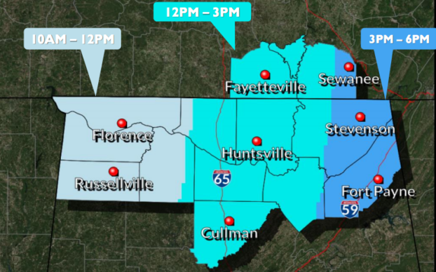
“We are monitoring a line of storms that is developing pretty far west of Alabama,” meteorologist Jessica Chase said. “This line should move into north Alabama around 10 a.m. and pass through into Georgia around 6 p.m.”
Chase said the line of storms could produce wind gusts up to 70 mph, with sustained winds of 25-35 mph, and carries the possibility of tornadic activity. Forecasts show the storms moving into Morgan County around noon.
“The entire area won’t be under the threat of severe weather the entire six-hour window,” she said. “The risk for sever weather exists, but it will move through fairly quickly.”
Chase also said the NWS was monitoring non-thunderstorm winds that could impact the area on Saturday.
“We could see non-thunderstorm winds up to 40 or 50 miles per hour,” she said.
Chase said people, especially those in higher elevations, should plan accordingly for the potential for sustained winds.
“It would be best to go ahead and secure anyone outdoor items today, because tomorrow will be very breezy all day,” she said.
In the event of serious weather, residents can seek shelter at multiple locations throughout Morgan County.
“Shelters in our area typically open when a tornado watch has been put into effect,” Morgan County EMA’s Brandy Davis said. “Since we know these storms are coming, some shelters may choose to open early. That decision is made by the actual shelter itself, though.”
For a complete listing of shelters, please visit https://www.morgancoema.com/shelters.
